in de Poitou Charentes

 The Island of Aix
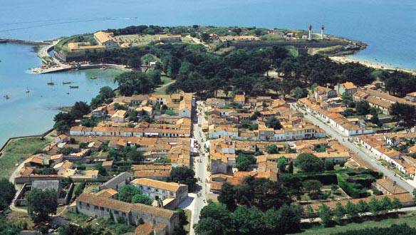
The Island of Aix, often called Island Dais or Island of Ay in a distant past, has the shape of a green and sand crescent with a slightly marked relief which stretches on 130 hectares with beaches, creeks and rocks. Three kilometers long and 600 meters wide, its central part is sometimes covered by the spring tides. You can stride around it in two hours at a brisk pace, and in less time on horseback or by bicycle... Near its shores, the Fort Enet and the impressive Fort Boyard, made known up to Quebec through a successful television game show, watch over Aix, the most meridional island of the Ponant.
The village to which you have access through the drawbridge of the harbour is particularly representative of our country’s military architecture. Indeed, we owe to Vauban and Ferry, the first fortifications of the island, and the tracing of the village with its three large arteries radiating from the field of maneuvers. The major construction projects carried out under Louis the XVI, later under the Empire, and thereafter, have not changed its general physiognomy that, henceforth the law protects from time’s effects and the more fatal ones which are human errors and thoughtless decisions. As the first visible testimony to the Island’s history of the eleventh century, the Saint-Martin church and its crypt were remarkably restored in 1970. These were reopened to the faithful and to visitors, just as in the case of the famous Emperor’s House which has been open to the public since 1928.
The old families of Aix are mostly from the neighbouring islands, Ré and Oléron, but also reflect different people’s origins stemming from the hazards of military life and history. For instance, there is an Acadian branch issued from the " Grand Derangement " in Canada in 1758. The inauguration in 1994 of the Quai of Acadie with his Excellency Mr. Benoît Bouchard, Ambassador of Canada to France commemorated the role of the Island within this tragedy. |
|


 Print uw selectie


